The Process of Documenting
Oregon’s “Trail of Tears”
This project is a work in progress: The Rogue River Trail of Tears has now all been photographed and printed including photographs near each of the 28 camping locations they stayed each night as well as several other important locations related to the removal.
I hope to continue this project to include other instances of forced removal in Oregon, including along the coastline as well as in Eastern Oregon. If you have any contacts or would like to help in some way, please reach out via my contact link on my website. I am still accepting donations to help finish this story.
Artist Statement
On the morning of February 22nd, 1856, U.S. Indian Agent George H. Ambrose carried out his orders from General Joel Palmer to forcefully remove and march several hundred indigenous men, women, and children from their aboriginal homeland in Southern Oregon to a Reservation in the Mid-Willamette Valley 263 miles away. This thirty-two-day journey was filled with deceit, suffering, death, and murder.
This project started with several years of preparation and research, reading through thousands of historical letters, looking over old survey maps from the 1850s, and utilizing satellite imagery from today. I retraced the entire route and I was able to locate bygone roads that are no longer in existence while following others that are still here today. I made these photographs using an antique wooden view camera and the wet plate collodion photo process from the 1850s and paired them with the journal entries written in the same time period. These landscape photographs illustrate the fraught expedition that Ambrose detailed in his daily journal. The imperfect photos play off the serendipitous technical flaws to create ghostly images that echo the grim history of the past and capture the forgotten and seldom told story of Oregon's “Trail of Tears.”
You can view the photographs of this project here:
Project Development
My story with this project began in 2018. I knew that for my next photographic series, I wanted to explore Oregon’s history—specifically, Euro-American settlement and its lasting impact on the land, culture, and existing communities. These echoes of the past still resonate strongly today.
As I searched for direction, I began researching and retracing the route of the Oregon Trail. According to the Bureau of Land Management, only 300 miles of the original trail remain. However, through satellite imagery and site visits, I came to believe that far more of the trail still exists—if only as subtle traces etched into the landscape. My goal became to document how the Oregon Trail appears today and to examine how its presence continues to shape the local communities along its path.
Realizing the project needed greater depth, I shifted my focus toward the conflicts between settlers and Indigenous peoples, uncovering overlooked yet significant stories that have long been forgotten.
In January 2020, I gave an artist talk about my photo essay Long Summer Days. During that event, I met another local photographer who invited me to his studio and introduced me to the wet plate collodion process—a photographic technique from the 1850s.
Around this same time, my father was diagnosed with ALS, though I had long suspected he had been living with symptoms for years before his official diagnosis. By 2020, his condition required that either my wife or I remain home full-time to care for him. Between this and the pandemic shutdowns, I used that period to dive deeply into the research that would form the foundation of this project.

(Left) Pouring one of my first plates. January 2020 (only several months before the shutdowns)

(Above) My first portable darkroom out of the back of my trunk. Photographing the Oregon Trail in Baker City, Oregon.
Research & Shift of Focus
I began my research by reading approximately 800 pages of transcribed letters from the Oregon Superintendency Correspondence, sourced through Southern Oregon History, Revised. These writings primarily consist of correspondence between the Bureau of Indian Affairs, U.S. government officials, military personnel stationed in the Oregon Territory, and private citizens.
From there, I located microfilm reels in the National Archives database containing the original letters. While examining these documents, I discovered the journal of George H. Ambrose, who chronicled his experience during the forced relocation of Native American communities from Southern Oregon to the Grand Ronde Reservation. His journal, remarkably detailed and recorded daily, compelled me to narrow my focus to this specific journey—Oregon’s own Trail of Tears.
To better understand the geography of these events, I obtained original survey maps created in the 1850s and 1860s from the Bureau of Land Management. By aligning the historical township and range coordinates from these maps with present-day satellite imagery and Google Earth data, I was able to overlay and superimpose the antique maps in Adobe Photoshop. I then retraced the original roads and transferred their routes to current GIS mapping systems. This process revealed the historical locations of old roads, camp sites, and other significant landmarks, while also providing precise GPS coordinates for field research and documentation.
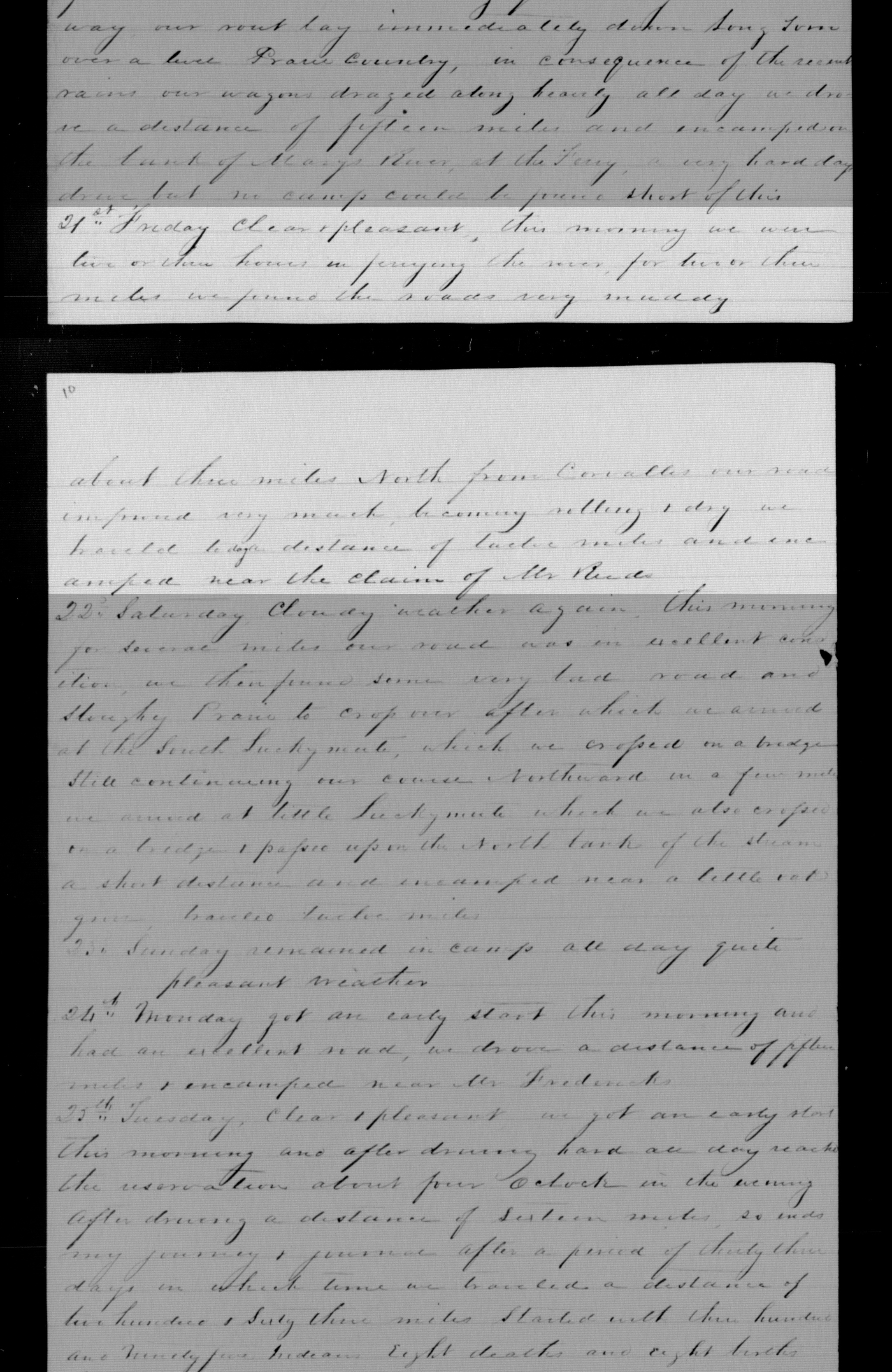
From G.H. Ambrose’s Journal: “…We traveled a distance of twelve miles and encamped near the claim of Mr. Reed.”
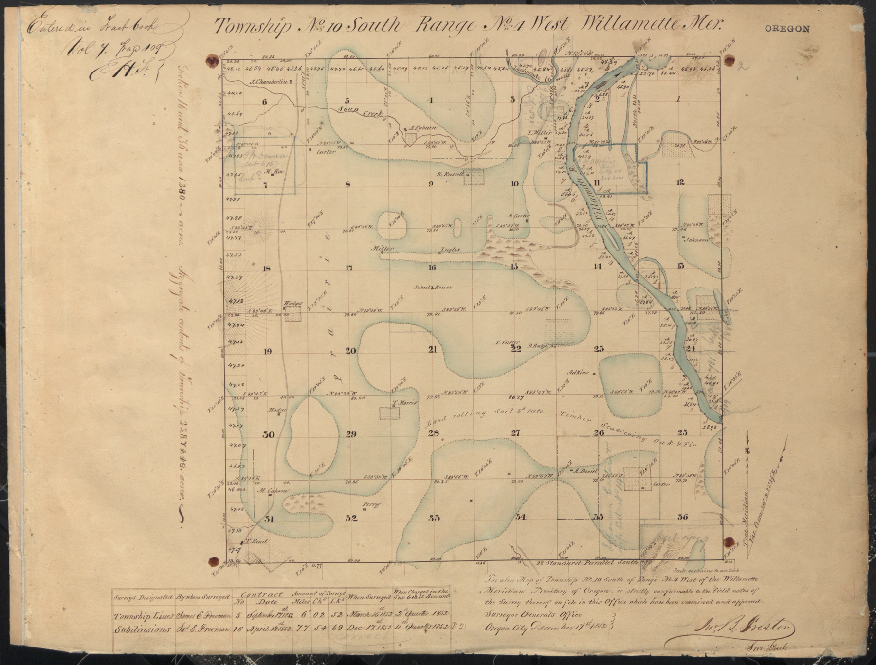
Survey map from 1852 of North Corvallis, Oregon

Current Township and Range map of North Corvallis, Oregon.

Tracing the original road in Adobe Photoshop.

Information is stored on separate layers in photoshop, making it easy to utilize both maps at once.

The original road is traced onto a modern map. Making it easy to distinguish current roads and mark GPS locations.
And I did this for the whole route - all 263 miles.

Additional Information & Photos
Many people today are unaware that Oregon had it’s own Trail of Tears, but even more are unaware that we have had many instances of forced removal of tribes from their aboriginal homelands. This became a methodical and systematic approach for the US Government. Text books and manuals were created by the Government for US Military, Superintendents of Indian Affairs, and US Indian Agents to follow in regards to removal and establishing reservations.

Tusday, January 29th, 1856
”There was an Indian man missing in the morning and could not be accounted for by any person in camp; after searching some two hours we found his blood where he had been murdered and thrown into the Creek; no trace of the murderer suspicion rests upon a Klickitat Indian (Joe), Rained through the day road very bad traveled about five (5) miles.”
- R. B. Metcalfe, Sub-Indian Agent

Columbia River
March 27th, 1856
“We reached the lower Cascades early in the day, where, selecting a favorable place for the purpose, I disembarked my men and gun on the north bank of the river, so that I could send back the steamboat to bring up any volunteer assistance that in the mean time might have been collected at Vancouver.
The Columbia River was very high at the time, and the water had backed up into the slough about the foot of the Lower Cascades to such degree that I left my only a narrow neck of firm ground to advance over toward the point occupied by the Indians. On this neck of land the hostiles had taken position, as I soon learned by frequent shots, loud shouting, and much blusteringly they, by the most exasperating yells and indecent exhibitions, daring me to the contest.
After getting well in hand everything connected with my little command, I advanced with five or six men to the edge of the growth of underbrush to make a reconnaissance. We stole along under cover of this underbrush until we reached the open ground leading over the causeway or narrow neck before mentioned, wen the enemy opened fire and killed a soldier near my side by a shot which, just grazing the bridge of my nose, struck him in the neck, opening an arty and breaking the spinal cord. He died instantly.“
- P.H. Sheridan
Photographs of My Mobile Wet Plate Darkroom

My wet plate collodion set up on location at The Grand Ronde’s old Fort Yamhill State Park. The location of the block house that guarded the reservation.

5x7 Kodak view camera and dark cloth on location at The Grand Ronde’s old Fort Yamhill State Park.
Some people have asked to contribute and help me pay for supplies and travel. If you would like to donate to help me finish this project. I added an option down below.
Project funding and support provided by:

Oregon Arts Commission, National Endowment of the Arts, The Kinsman Foundation,
Albany Regional Museum, and Focal Point Photography